
Philippines Weather News — 7-Day Outlook

Magic 89.9
9 hrs ago
Official PAGASA
Saturday, September 26, 2026
🌧️ Main weather situation today
The Philippines is being affected by the Intertropical Convergence Zone (ITCZ), bringing cloudy skies, scattered rain and thunderstorms particularly across parts of the Visayas and Mindanao. Other areas, including Luzon and Metro Manila, can expect partly cloudy to cloudy conditions with localized rain showers or thunderstorms.
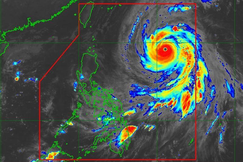
Meanwhile, Severe Tropical Storm Queenie (international name Surigae) is inside the Philippine Area of Responsibility. As of the 5:00 PM PAGASA bulletin, Queenie was about 605 km east-northeast of Itbayat, Batanes, with maximum sustained winds of 110 km/h and gusts up to 135 km/h. PAGASA says it is unlikely to directly affect the country, and there are currently no Tropical Cyclone Wind Signals.
Queenie is forecast to move northward and exit the PAR between Sunday afternoon and evening, September 27, while potentially reaching typhoon strength over the waters outside the Philippines.
7-Day national Forecast
Sat Sept 26, 2026
🌦️ Partly cloudy to cloudy. Localized showers/thunderstorms; wetter conditions possible in parts of Visayas and Mindanao.
Sun Sept 27, 2026
🌧️ ITCZ continues to bring scattered rain and thunderstorms over much of Visayas, Caraga, Northern Mindanao, Zamboanga Peninsula and Palawan.
Mon Sept 28, 2026
🌧️ Similar ITCZ influence, particularly over Visayas and portions of Mindanao; isolated thunderstorms elsewhere.
Tues Sept 29, 2026
⛈️ Scattered rain/thunderstorms over Caraga, Northern Mindanao and most of Visayas; isolated afternoon/evening thunderstorms elsewhere.
Wed Sept 30, 2026
🌦️ Another circulation/trough east of the Philippines may increase rain and thunderstorms over Visayas, Caraga and Northern Mindanao.
Thu Oct 1, 2026
🌦️ Continued possibility of scattered rain/thunderstorms in the central and southern Philippines, with localized afternoon/evening thunderstorms elsewhere.
Fri Oct 2, 2026
🌧️ The trough may continue producing unsettled weather over portions of Visayas and Mindanao; localized thunderstorms remain possible nationwide.
🗺️ Regional outlook
Luzon:
Generally partly cloudy to cloudy, with isolated rain showers or thunderstorms. Metro Manila is expected to remain around the low-to-mid 30s °C during the day. PAGASA's Metro Manila forecast calls for isolated showers/thunderstorms.
Visayas:
A wetter pattern is expected. ITCZ-related cloudiness, scattered rain and thunderstorms are likely, with some areas potentially experiencing locally heavy rain and thunderstorms.
Mindanao:
Caraga and Northern Mindanao are among the areas expected to experience more persistent ITCZ-related rain and thunderstorms. Zamboanga Peninsula can also see scattered rainfall.
Palawan:
Rain showers and thunderstorms remain possible, with Palawan included among the areas affected by the ITCZ.
🌀 Queenie situation
As of the latest PAGASA bulletin available today:
- System: Severe Tropical Storm Queenie / Surigae
- Location: ~605 km east-northeast of Itbayat, Batanes
- Maximum sustained winds: 110 km/h
- Gusts: up to 135 km/h
- Movement: Northward at 15 km/h
- Wind signals: None
- Direct land impact: PAGASA says unlikely throughout the forecast period
- Expected PAR exit: Sunday afternoon/evening, Sept. 27
Coastal waters around Isabela, northern Batanes and eastern Davao Oriental may reach waves of up to 2 meters, so small-craft operators should exercise caution.